 |
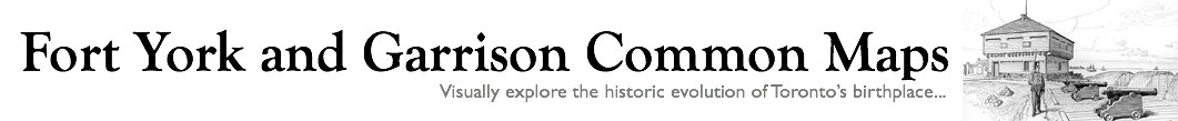
| Aerial view 1940/46. A: Massey-Harris. B: Lunatic Asylum. C: Mercer Reformatory. D: Toronto Carpet Factory E: Canadian National Exhibition. Courtesy City of Toronto Archives: f1244_it2420 |
In 1870 fully 150 acres of the Reserve, much of what later became Liberty Village, were granted to the Province of Ontario for growing food and for agricultural therapy at the Lunatic Asylum. The area was notably inaccessible because of the three railway corridors that cut across it. As well, up till 1876 King Street dead-ended in the grounds of the Crystal Palace. Notwithstanding these handicaps, not long after acquiring the land the provincial government began to locate other institutional uses there, and to offer sites for industry that valued good rail connections and being near prison labour.
In 1872 twenty acres were given over to a new Central Prison (designed by Kivas Tully). Also that same year the Canada Car Company, predecessor to the John Inglis Company, was given the freehold on a previously-leased 5-acre site where the GTR crossed Strachan Avenue. In 1878 an additional 11 acres was set aside for for a reformatory for females. The Massey Manufacturing Company, having decided to move from Newcastle, ON., to Toronto, was granted a six-acre toehold near King and Strachan in 1879 that grew subsequently until it totaled 11 acres. Finally, in 1886 the Province auctioned off 58 acres bounded by King, Dufferin and the Grand Trunk--effectively the whole west end of Liberty Village. This with other land sales ended the idea of an Asylum Farm in the city.
Plates 20 and 21 below from Charles Goad's atlases published in 1884 through 1924 show well how the Liberty Village area filled with industrial development during that period. The neighbourhood's transition from light industry to new service, commercial and residential uses started in the 1980s and continues. For a photo essay of the area from the transition period and earlier see here.


In 2005 City Council voted to include 38 properties in the Garrison Common North study area, many of them in Liberty Village, on the Toronto Inventory of Heritage Properties.
Proceed to Next Chapter: Aerial Photographs