Agricultural fairs have been held throughout Upper Canada since the early 19th century. Williamstown in Glengarry County is home to the one that has operated longest without a break. The first province-wide fair took place in Toronto in 1846, but then the location was rotated annually among Kingston, London, Hamilton and Toronto. The
Crystal Palace of 1858 -- designed, as it happens, by surveyors and engineers Sandford Fleming and Collingwood Schreiber -- was built to house the fair at Toronto that year.
By 1878 the Toronto City Fathers were tiring of seeing the fair in their midst only at intervals, and of having to maintain a large building that stood empty most of the time. Accordingly, in 1879 they fostered the organization of the Industrial Exhibition Association to operate an annual fair at Toronto and the CNE was born. The old Crystal Palace was taken apart and moved to the new fair grounds, east of Dufferin Street between the Toronto-Hamilton rail corridor and Lake Ontario, which has been the heart of the CNE since.
1858 Ellis: Map of the City of Toronto, Canada West
1872 Wadsworth & Unwin: Map of the City of Toronto (with manuscript additions shewing real estate exemptions from taxation, 1878)
[1884, 1894, 1903, 1913, 1924] Goad: Atlas of the City of Toronto, Plate 20
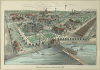
1889: Exhibition Grounds Bird’s Eye View
1906 Unwin: Plan Shewing Exhibition Park and Garrison Commons, Toronto
[1906, 1921, 1928, 1940, 1953, 1963, 1974, 1985, 1994, 2012] Anon: Map of the Canadian National Exhibition Grounds
1995 Archaeological Services Inc.: Composite map of the New Fort, circa 1840-1950 within the context of the CNE grounds
Proceed to Next Chapter:
Wharves and Waterfront